
Heat has emerged as one of Europe’s greatest enemies. In the new series ‘Europe battling heat‘, IO discovers how cities (can) arm themselves against it. Today: a simulation model for urban planning.
As climate change progresses, extreme weather events such as prolonged hot spells, storms, and heavy rain occur more frequently, and cities feel the strain. The new urban climate model PALM-4U will allow municipal staff and city planners to simulate the effects of their planned construction projects on the urban climate so that they can gauge the consequences of extreme weather events before they happen, improve quality of life in urban areas and protect the health of the sick and the elderly. Researchers at the Fraunhofer Institute for Building Physics IBP created the user interface for the simulator, putting their many years of expertise in fields such as hygrothermics and indoor climate to good use.
- Fraunhofer researchers developed a simulation model to understand the tipping points that could lead to a climate collapse.
- The model combines complex Earth system processes like sea ice melt, permafrost thaw, and monsoon dynamics.
- It allows testing intervention strategies to prevent crossing catastrophic tipping points that would accelerate climate change.
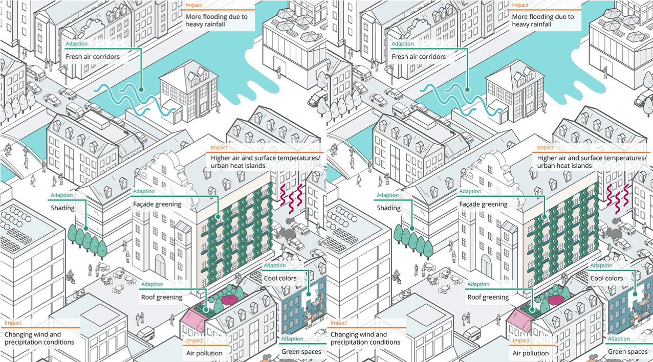
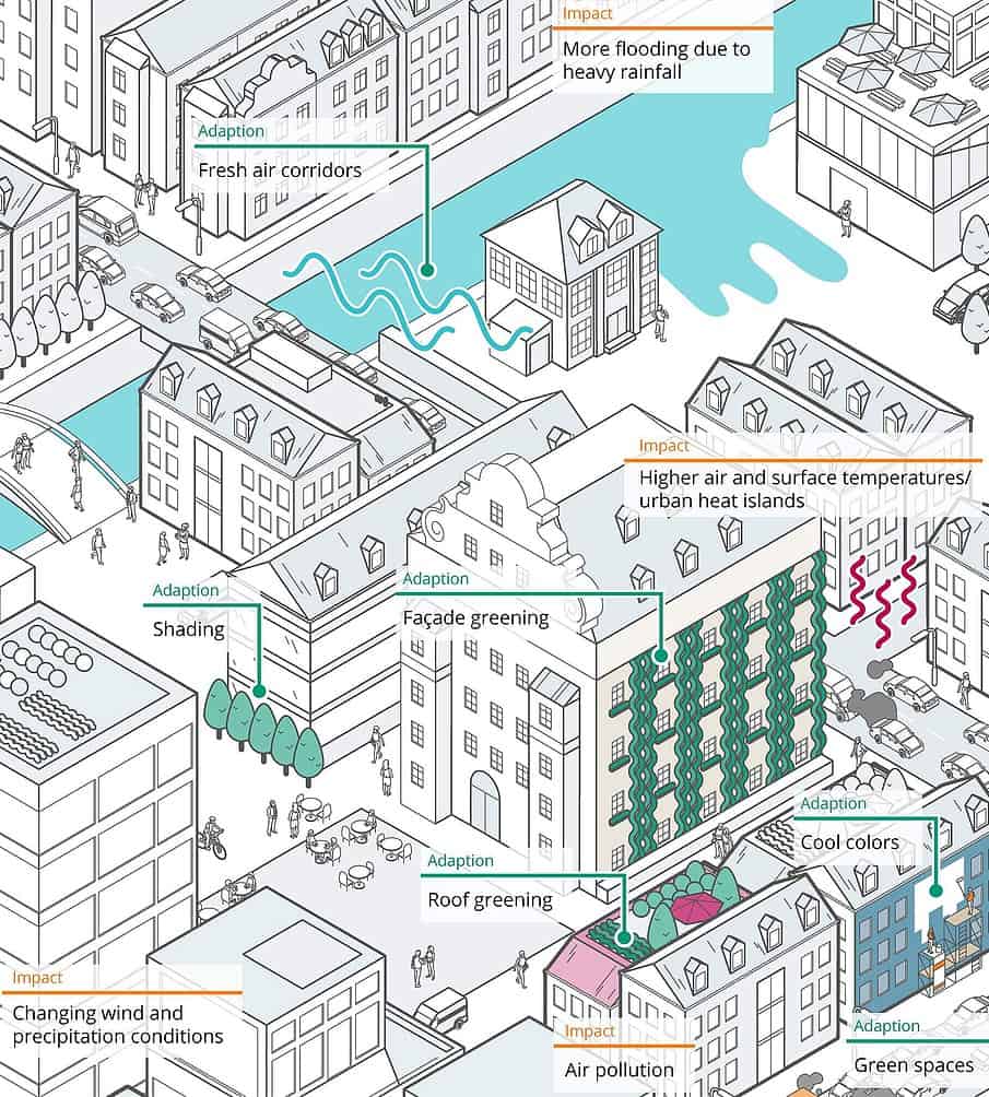
Climate change challenges us all, and city planners are no exception. Researchers expect the incidence of prolonged hot spells, heavy rain, and storms to increase. “Densely populated urban areas are particularly susceptible to extreme weather events, and they do more than just affect people’s well-being. For individuals that are weaker or experiencing poor health, e.g., people in retirement homes, daycare centers, and hospitals, extreme weather events can be dangerous,” explains Matthias Winkler, a hygrothermics expert at Fraunhofer IBP. This is why cities and municipalities are working intensively on planning construction initiatives that could help mitigate the consequences of climate change and make city climates manageable to a certain extent, thus maintaining and improving the quality of life in urban areas.
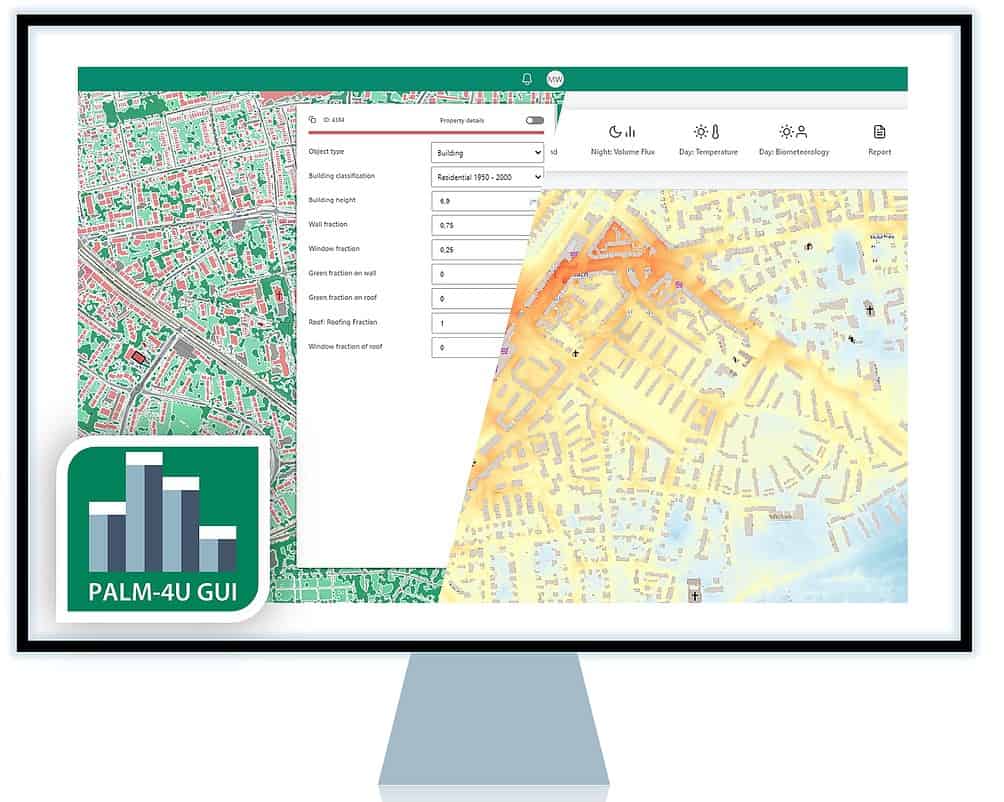
The PALM-4U urban climate model allows users to depict and simulate how construction projects impact the urban climate, which makes it a valuable resource for planning offices and municipalities. It could be used to simulate greening a facade or planting trees, for example, to determine whether these measures improve the citizens’ thermal comfort levels. The urban climate simulator also makes it possible to identify spaces particularly severely affected by high temperatures and model the impact that construction projects such as installing green spaces or unsealing surfaces would have on the climate in the surrounding areas before implementing them. Mr. Winkler and his team contributed to the complex tool by developing the PALM-4U GUI. This user interface has a straightforward, logical structure, allowing users to configure all the necessary functions and parameters.

Urban Climate Under Change
PALM-4U was designed and developed as part of the Urban Climate Under Change initiative by the German Federal Ministry of Education and Research (BMBF). “With PALM-4U, users can not only determine the impact that construction projects will have on the climate, but also quantify it precisely,” Mr. Winkler points out. This could also allow planners to assess whether investing in a particular building project would ultimately be profitable or whether another initiative might have the same effect at a cheaper price.
This tool’s data basis comprises meteorological data from sources such as the German weather service (Deutscher Wetterdienst, DWD) and regional climate models. Municipalities can also incorporate weather data — such as temperature, humidity, wind speed, and even the level of fine particulate matter in specific squares in the city — from any regional measurement stations they may have. In addition, the data basis will contain extensive geodata and city maps that show streets, squares, houses, bodies of water and green spaces. The more detailed and accurate the depiction of these elements is, the more reliable the PALM-4U simulation will be.
Thermal comfort, wind comfort, and pollution levels
Urban climate analyses tend to focus on three groups of topics, beginning with thermal comfort and cold air flows at night. This topic includes the thermal load in buildings, squares and streets caused by high-pressure weather conditions and whether there are enough ventilation corridors to aerate the region overnight. For the second topic, wind comfort, areas with different wind comfort criteria are identified based on the simulations and local wind statistics. This information can help draw conclusions regarding potential uses for the spaces in question, such as outdoor catering. The third topic involves analyzing the airborne fine particulate matter from sources such as domestic fires and automotive traffic, provided the available data.

Where needed, the PALM-4U GUI offers an expert mode in which users can add further simulations based on their specifications. “The tool is scalable and can model the climate of an entire city or an individual neighborhood, district, or square,” explains Mr. Winkler. To give just one of many possible examples, municipal staff and city planning offices can use the tool to test the effects of a high-rise on the building next door, the surrounding streets, or the entire district.
Comparing different planning variants
The system comes pre-programmed with typical meteorological conditions suitable for simulating individual problems; the users can adjust these conditions to suit their own local specifications. For example, when studying thermal comfort, users can apply a model of summertime high-pressure weather conditions.
“With PALM-4U, we can also compare different planning variants with each other. This means we can avert typical planning errors early on, which would otherwise result in situations where children at a poorly designed playground would be exposed to high levels of heat, for example,” explains Sabine Giglmeier, a business development manager in the Hygrothermics section at Fraunhofer IBP. The simulator could also work out tricky climate issues from as early as the planning phase when constructing an extension for a retirement home or hospital, for example.
Support and advice for municipalities
The simulation results can be analyzed and displayed via the user interface. When developing the user interface, the Fraunhofer IBP researchers incorporated feedback from experts working in practical fields. “We collaborated with municipal staff from cities like Berlin, Stuttgart, and Dresden to gain a deeper understanding of their specific requirements and to optimize the system’s suitability for practical application,” says Mr. Winkler. The software is cloud-based, meaning there is no need to go through the expensive installation process and integrate it into existing IT systems.

Fraunhofer IBP also aims to support cities and municipalities when it comes to actually using PALM-4U. “We offer training courses for users and provide advice on developing individual solutions for a city during the actual operation of PALM-4U. We also conduct urban climate studies when requested,” explains Ms. Giglmeier.
Related Posts


