

The province of Brabant will install a camera in ten inspection cars to scan the 560-kilometre provincial road in Brabant accurately. This is done in the context of the ‘Talking Maps’ study, which processes the recorded data directly into a High Definition (HD) card that contains up-to-date information for autonomous cars.
The purpose of the test is to determine whether inspection vehicles can indeed serve as sensors, how quickly they collect sufficient data for a good map and whether the map can also help to manage the roads efficiently. The trial lasts a maximum of two years and is a collaboration between the province of North Brabant, the Ministry of Infrastructure and Water Management and the companies V-Tron and AND.

Autonomous cars are equipped with vehicle sensors that require continuous road information. Based on these data, the car knows where it is located, how to drive and how to react in traffic. Commissioner Christophe van der Maat said: “As the province of North Brabant, we want to enable the arrival of the autonomous car and preferably also to speed up its arrival. That is also why we are making our inspection cars available for this test. With the information on the maps, an autonomous car can, for example, also know exactly what the surroundings look like in case of fog. But the HD cards are not only used for autonomous driving. As road administrators, we may also be able to use this information to see whether the traffic signs are properly in place, whether the road markings are still of sufficient quality, et cetera. This kind of up-to-date information enables us, as road administrators, to make increasingly efficient choices for road administration.”
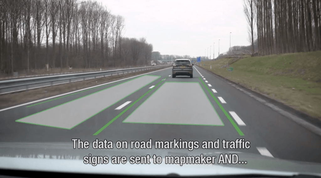
Hugo van der Linde, CEO of AND: “Until now, collecting such road information and translating the data in the maps has been a time-consuming and complex process. With this technique, the camera detects and interprets everything it encounters from the inspection car: traffic signs, road markings, speed limits, number of lanes, zebra crossings, manhole covers and other objects on the roads. AND translates this information directly into HD maps, which makes the information provision faster and much more detailed.”

Exploration with the HD cards is a multi-stage process. First of all, the lines and road signs are accurately mapped out. Other road information will follow later. The camera only records information about the road. No license plates or other road users are scanned so that the privacy of others is not compromised.
Related Posts


