

As of this week, the final section of the heat stress series. This eleventh episode is devoted entirely to the Twente region, which was mapped out in exactly the same way as the rest. With the help of no less than sixteen(!) maps, a very complete picture rolled out here in which not only inner cities, but also villages and outlying areas were covered.
The thermometer at Twente Airport ticked up to a tropical 32.6 C° on Friday afternoon just after 1:30 pm back on August 12. But what were conditions like on the ground? This is what the algorithm of the NASA ECOSTRESS satellite knew the answer to. Almelo is leading the way this time.

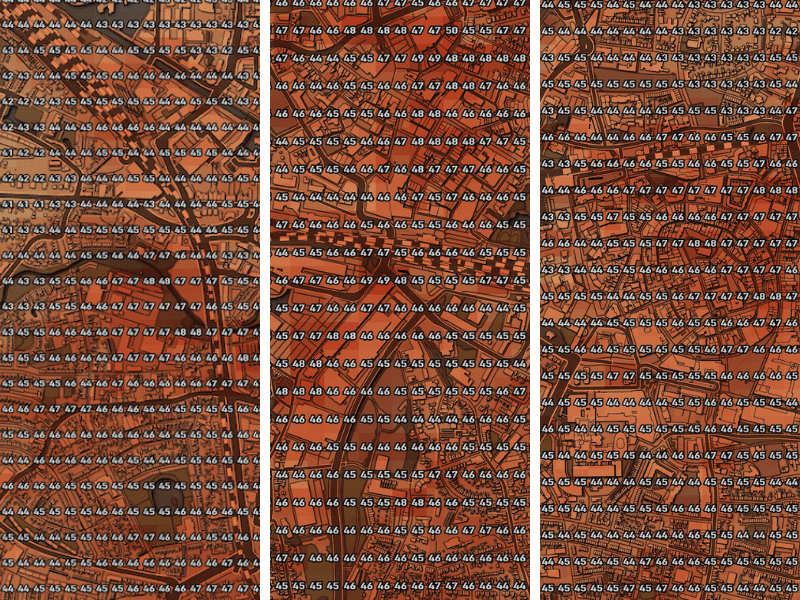
Almelo
Of the three cities in the region, the inner city climate seems to be the most pleasant in Almelo, where the city center was drastically overhauled in recent years. The ambitious and controversial plans of the municipality have now been completed, which means that the port now extends all the way to the shopping center. This is supposed to make the streetscape more attractive and Almelo more popular among owners of pleasure yachts. As to whether this has succeeded? No idea. That’s not what this column is about.

But what can be seen is that the plan has provided a significant amount of cooling in the western part of the downtown area with ground temperatures hovering around 44-45 C°. Still a degree or 2 or 3 degrees lower than the shopping streets just down the road. Has Almelo managed to solve part of it’s heat island problem this way? It would seem so. Yet this does not mean that there are no areas for concern to be found anywhere here.
While things seem to be going reasonably well in the downtown area, it is somewhat different elsewhere in the city. In the business parks in the north of the city, ground temperatures run as high as 53 C°, while many residential areas are also remarkably hotter than downtown. This is fairly unusual. A more standard situation with a ” warmer” inner city and slightly cooler residential areas can be seen, for example, in Wierden, in the far west on this map.
These very hot residential neighborhoods are mostly found around the city center and in the western part of the city, such as Rohof and De Riet. More modern suburbs on the outskirts of the city remained about five degrees cooler on the ground. Where you can find the fewest drops of sweat inside the built-up area, Rogmanspark and Aadorp are considered the absolute best places to be. The latter is notable for its location around the hot business parks to the north, with variances of as much as 16 degrees less than a kilometer away.
Hengelo
The second-largest city in the region has a questionable first in its pocket with the Thiemsburg Mall. A temperature above 50 C° has not yet been observed in any of the more than 20 cities since this column was launched. To say that this inner city could use some ambitious cooling measures like Almelo would appear to be an understatement.

The areas with surface values above 45 C° stretch across almost the entire shopping area. This makes the coolest spot in the center of Hengelo hotter than the hottest spot in the center of Maastricht. Escaping from the heat in this city center is barely tenable. The entertainment area in the hot west of the inner city lags several degrees below the shopping area.
For that matter, we do not have to look very far for large differences in temperatures. The northern new housing estates (around 40℃) and neighboring Borne (average 42℃) to the northwest reveal that not the whole area of Hengelo is a colossal hotspot. Global rule of thumb: the further away from the blazing hot city center, the less heat stress. How widespread is this problem? Substantial.
Because it seems that Hengelo has knocked the crown off neighbor Enschede – which had been in the lead in the inner-city heat island ranking ever since the first episode.
East Twente
The super-sized final map of this eleventh episode contains nine of the sixteen region maps with the interactive zoom tool at full resolution. The fact that the sparrows are not literally falling off the roof all over Twente is obvious here. Aside from the hot inner cities of both Hengelo and Enschede and some industrial estates where the mercury rises to as high as 54℃ the issues in most of the surrounding villages remain quite manageable. Especially in Borne and Delden, the situation appears to be perfectly under control.
Are heat islands chiefly an affliction that torments city dwellers? Based on the data from Twente, you could almost say so. But that does not necessarily mean that there isn’t any work for smaller municipalities to do. After all, the most expansive specimen of all can be found on the southern edge of Oldenzaal. Even though not many people live in this part of town, that does not mean that absolutely nothing needs to be done here. You can use the this zoom tool below to zoom down to street level.
Related Posts


