
Sinkholes are an ever-increasing phenomenon, mostly due to failures and breakages of underground, often obsolete utilities (sewers and water pipes).
On top of that, quite a few cities in Italy and other European countries with a long history have stratified foundations. These kinds of municipalities are partly built on the remains of other buildings. It is not unusual in Rome for a parked car to simply slide under the road surface, as happened just last May:

Detecting sinkholes in an urban environment is not easy. A group of two Italian research institutes and four engineering companies have applied a combination of technologies to specifically detect cavities in the subsurface before it is too late.
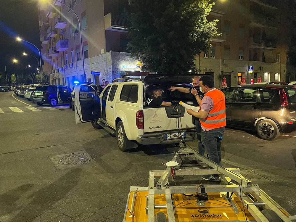
We asked Vittorio Rosato about the significance of this new approach. Rosato heads the Laboratory for the Analysis and Protection of Critical Infrastructure at ENEA, a state-run scientific agency in Italy. When we called him, he was just taking measurements in the street with his colleagues from INGV, the geophysical and volcanological service of the Italian government.
Hope we are not interrupting your research!
No, we have just finished our work for the day. We are now in a residential area on the south-east side of Rome and have collected our data. We are going to analyze the data at the laboratory.
What data are you talking about?
Data about the subsurface. We’ve combined four existing technologies so that we can perform an analysis to identify spots in the subsurface where there may be some anomalies.
What kind of anomalies?
Then we are talking about cavities that are pretty much directly below the road surface or buildings that were created ad hoc or over time. It is known that in the area where we are working now, soil was excavated to obtain building materials over a hundred years ago. The excavation was plugged up and buildings were later erected when the city expanded. We know that there is a greater chance of sinkholes here than somewhere else.

What does the new method involve?
We start by taking and analyzing satellite images of a particular area, for example the south-east corner of Rome. These are used to map out large areas and identify physical properties of the surface. This is how we can detect the first anomalies. Based on this, we carry out targeted surveys on the street.
If a suspected section is identified beneath which a ‘vanishing point’ is forming, we use a multifrequency georadar to examine it. This makes a vertical cross section three to four meters below ground. The frequency range is between 200 MegaHerz a 2 GighHerz. This provides us with a kind of ultrasound of the subsurface.
What other technologies do you use?
We subsequently conduct a capacitive geoelectric survey to get a picture of the electrical conductivity of the subsurface. This shows important variations in the resistivity of the soil. Using geoelectric surveys, we can go deeper into the ground and reach six, seven, sometimes as much as ten meters. The large variation in resistivity can be related to a structural anomaly in the soil.

We also use drones with infrared cameras to do thermal monitoring, especially to detect water. This could indicate a broken water pipe, where the water is washing away the surface of the soil.
How are sinkholes generally being detected these nowadays?
I don’t want to say ‘let’s take a gamble’, but now it’s pretty much a matter of drilling holes in the subsurface and sending a camera down in places where cavities are suspected.
Our method is consequently much more targeted. It saves time, costs and is less invasive to the above-ground infrastructure, because streets do not have to be cordoned off unnecessarily.
Is this method also suitable for other European countries and areas?
It definitely is. It depends a bit on what type of soil we are talking about. But sinkholes can occur in all sorts of soils. Older cities and I think perhaps also Amsterdam and Paris, for example, were often built in different time periods. Their stratified construction can regularly cause pockets to form where subsoil gives way.
How unique is your method?
All the technologies used are readily available on the market and anyone in our profession can use them. But the combination of technologies that we put into practice is, I think, unique. Especially their use in urban environments.
The use of similar technologies (particularly georadar) is also very useful to discover the presence of archeological remains hidden under the ground.
We are quite fortunate though, to have Rome, where there are so many holes in the ground. We have been doing this trial for over a year now with considerable success and we are getting all the cooperation we need from the municipality of Rome. This would not have been possible so soon in other cities.
One more thing: can this method also be useful in ‘predicting’ earthquakes?
No, earthquakes occur so deep in the earth that georadars, among other things, are not helpful.
Read about how animals can predict earthquakes.
Related Posts


